Trail Walking Les Rues-des-Vignes - Vaucelles 12.3Km Dén P 150m - Photo

Vaucelles 12.3Km Dén P 150m

© OpenStreetMap contributors
Length
Length
12.3 km
Max alt
Max alt
142 m
Uphill gradient
Uphill gradient
150 m
Km-Effort
Km-Effort  
14.3 km
Min alt
Min alt
69 m
Downhill gradient
Downhill gradient
148 m
Boucle
Boucle
Yes
Creation date :
2017-03-11 00:00:00.0
Updated on :
2019-02-08 18:55:08.932

(0 Reviews)

Walking
Walking
2h14
Difficulty : Easy

Scan this QR Code to open this trail in the SityTrail application

FREE GPS app for hiking

Logo SityTrail SityTrail

IGN / Geographical institutes

Download SityTrail from the App Store Download SityTrail from Google Play

Logo SityTrail SityTrail World

The world is yours!

Download SityTrail from the App Store Download SityTrail from Google Play Download SityTrail on Huawei AppGallery

About

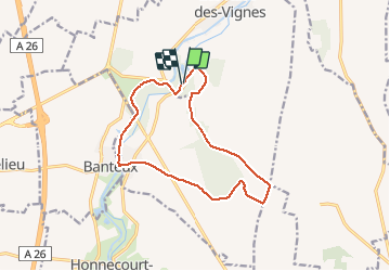
Trail Walking of 12.3 km to be discovered at Hauts-de-France, Nord, Les Rues-des-Vignes. This trail is proposed by alain62rando.

Description

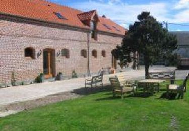
Départ parking Abbaye de Vaucelles
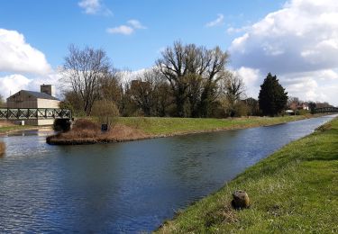
Belle randonnée en sous bois puis en plaine pour rattraper le canal de St Quentin (l'Escault)et longer celui-ci sur un chemin herbeux jusqu’au retour à l'Abbaye de Vaucelles

Elevation profile

Positioning

Country:
France
Region :
Hauts-de-France
Department/Province :
Nord
Municipality :
Les Rues-des-Vignes
Location:
Unknown
Start:(UTM)
515896 ; 5547236 (31U) N.

Trails nearby

Trail Walking Crèvecœur-sur-l'Escaut - Circuit des Mérovingiens - Photo
Walking

Walking

Very easy
(1)
Crèvecœur-sur-l'Escaut, Hauts-de-France, Nord, France
11.3 km | 12.7 km-effort
Unknown
Yes
Trail Walking Banteux - Circuit de Vaucelles - Banteux - Photo
Walking
tracegps

Walking

Difficult
(2)
Banteux, Hauts-de-France, Nord, France
12.7 km | 14.6 km-effort
3h 10min
Yes
Trail Walking Les Rues-des-Vignes - Abbaye de Vaucelles - Photo
Walking
Greg813

Walking

Medium
Les Rues-des-Vignes, Hauts-de-France, Nord, France
22 km | 25 km-effort
5h 39min
Yes
Trail Walking Bantouzelle - Autour de l abbaye de Vaucelles - Photo
Walking
terminio

Walking

Easy
(1)
Bantouzelle, Hauts-de-France, Nord, France
6.6 km | 7.4 km-effort
1h 39min
Yes
Trail Walking Bantouzelle - Autour de l abbaye de Vaucelles - Photo
Walking
terminio

Walking

Easy
Bantouzelle, Hauts-de-France, Nord, France
6.6 km | 7.4 km-effort
1h 39min
Yes
Trail Walking Honnecourt-sur-Escaut - Saint Jacques en Boulangrie -   Honnecourt sur Escaut - Saint-Quentin - Photo
Walking
tracegps

Walking

Medium
Honnecourt-sur-Escaut, Hauts-de-France, Nord, France
33 km | 37 km-effort
8h 0min
No
Trail Walking Les Rues-des-Vignes - Saint Jacques en Boulangrie -  Abbayte de Vaucelles - Honnecourt sur Escaut  - Photo
Walking
tracegps

Walking

Medium
Les Rues-des-Vignes, Hauts-de-France, Nord, France
6.4 km | 6.8 km-effort
1h 30min
No
Trail Mountain bike Honnecourt-sur-Escaut - Les hauts du Cambrésis - Honnecourt sur Escaut - Photo
Mountain bike
tracegps

Mountain bike

Medium
Honnecourt-sur-Escaut, Hauts-de-France, Nord, France
16.2 km | 18.9 km-effort
1h 45min
Yes
Trail Walking Crèvecœur-sur-l'Escaut - Circuit des mérovingiens  - Crèvecoeur sur l'Escaut - Photo
Walking
tracegps

Walking

Very difficult
Crèvecœur-sur-l'Escaut, Hauts-de-France, Nord, France
16.8 km | 19.2 km-effort
4h 10min
Yes


Close
My subscriptions